• Skip to main content

Hike NWA

How to start hiking in Northwest Arkansas.

  • Home
  • Explore
    • Cities
      • Bella Vista
      • Bentonville
    • Trail Systems
    • Trailheads
    • Trail Difficulty
    • Trail Surfaces
  • Plan a Hike
    • Getting Started
    • Which Trails are Hikeable?
    • Route Library
    • Beginners’ Hiking Guides
    • How to Navigate on the Trail
    • FAQs
  • About
    • Our Team
    • Contact
  • Get Involved
    • Lead a Hike
    • Donate

Trail Surfaces: What You’ll Be Walking On

Natural-surface singletrack of packed dirt, loose rock, and leaf litter winding into green woods

Trail Surfaces: What You’ll Be Walking On

Every route on this site carries a difficulty badge—Paved, Easy, Moderate, or Challenging. Those badges tell you how difficult the route is. They do not tell you what it feels like underfoot, and for a lot of new hikers that is the more useful question. This page answers it with photographs of the actual surfaces you will meet on Bella Vista and Bentonville trails.

“Natural surface” doesn’t mean soft · Packed dirt · Gravel · Leaf litter · Pine needles and duff · Loose rock · Rocky, eroded tread · Solid rock · Roots · Water crossings · Bridges & wood features

“Natural surface” doesn’t mean soft

You’ll see the phrase natural surface all over this site. It has a specific meaning, and it’s worth clarifying to avoid any confusion.

Paved is our only hard surface. That means the trail is asphalt or concrete, six feet or wider, with no rocks and no roots. Paved-surface trails are greenways and park paths, and strollers and wheelchairs do well on it (with some exceptions).

Everything else is natural surface, which simply means the trail is made of whatever the ground is made of—dirt, gravel, rock, and roots. Sometimes natural-surface trails are called “soft-surface trails,” but that is misleading. Soft-surface, natural trails do not necessarily have soft, cushioned, or gentle surfaces. On the contrary, plenty of natural-surface trail around here is solid rock, and likely the vast majority is loose or embedded rock over packed dirt that definitely doesn’t feel like you’re walking on a soft surface.

The rest of this page gives you an introduction to the variety of natural surface trails you can hike on in Bella Vista and Bentonville.

Packed dirt

Packed dirt is what you get when thousands of footsteps cross a dirt path. Many of the trails marked as Easy are packed dirt, as are many of the sidepaths that run along the edges of roadways.

Freshly built or recently rebuilt trail has not been packed fully yet, so it may be a little loose or crumbly until traffic and rain settle it. Packed dirt trails are also very likely to turn into mud when there is heavy rain, especially in areas that are sunken and retain water. Avoiding trails after rain if your footstep leaves an impression in the soft or wet dirt is best practice to prevent damage to the trails.
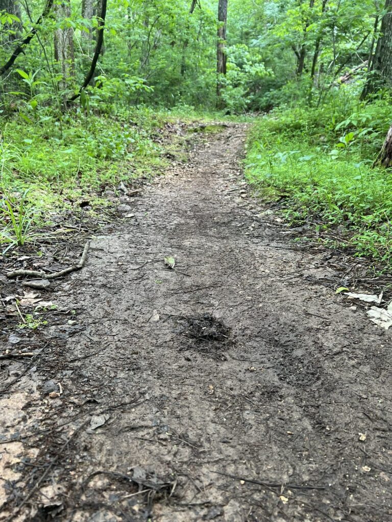
Smooth buffed packed-dirt singletrack winding through green Northwest Arkansas woods
Smooth packed dirt—the softest natural surface we have.
A narrow packed dirt singletrack trail running through green summer vegetation in Northwest Arkansas
Narrow packed dirt singletrack, worn smooth and easy to follow.
A wide packed dirt trail on Black Apple running through open sunlit woods in Bentonville
The wide packed dirt of Black Apple, which is about as easy as natural surface gets.
A wide flat packed-dirt hiking trail scattered with fallen leaves
Wide packed dirt with leaf litter and random rocks that have rolled onto the trail.

Gravel

Gravel is the workhorse surface—crushed stone spread over the tread to keep it firm and draining. Around here that stone is usually local limestone or chert, because that is what the ground is made of. It is generally stable, even, and pleasant to walk on.

The variety matters. Fine crushed stone with broken faces packs down almost like pavement, which is why trail builders prefer it to smooth rounded gravel. Coarser gravel with cobbles set into it stays firm underfoot but catches toes—especially when you’re on that last mile of your hike.

A wide Northwest Arkansas trail surfaced in pale gray crushed limestone gravel
Crushed limestone.
A gravel hiking trail with larger cobbles set into the tread, bordered by green vegetation
Packed dirt with gravel and larger stone set into it. It’s firm, but it’s also easy to trip over the larger embedded rocks.

Leaf litter

For several months beginning in autumn and through much of the winter, the trail simply disappears. Fallen leaves accumulate across the trail surface until the edges are guesswork and whatever is underneath—a rock, a root, a hole where a rock used to be—is completely hidden. After a rain, the leaves can be especially slick.

A narrow dirt hiking trail almost completely buried under fallen leaves in winter woods
In autumn the leaves erase the trail. What is under them—rock, root, or a hole where a rock used to be—is anyone’s guess.
Small gravel and dirt on a climbing singletrack hiking trail with a few fallen leaves
Early spring when the last of the leaves can still be seen along the edges of the trail.

Pine needles and duff

Anywhere pines stand overhead, the trail surface collects a layer of fallen needles, twigs, and dead vegetation. It is the closest thing we have to a genuinely soft surface, and it’s usually a pleasure to hike on.

A trail carpeted in fallen pine needles running through a stand of tall pines
A carpet of needles under the pines, soft and quiet underfoot.
A wide faint trail through open Ozark woods carpeted in fallen pine needles and forest duff with grass growing through
Fallen needles and forest litter build up on some trails. It’s springy underfoot, and it hides whatever is beneath.

Loose rock

This is the type of tread that often challenges people. Larger loose rock sits on the trail rather than in it. Walking on this type of surface can be hard on ankles and if you’re wearing thin-soled shoes, you will feel every single rock.

Loose fist-sized tan and pink cobbles covering the full width of an Ozark hiking trail
Loose cobble like this rolls under your foot.
Loose limestone and chert rocks the size of a fist or larger covering an Ozark hiking trail
Trail surface like this can easily cause a twisted ankle, so slowing your speed is necessary.

Rocky, eroded tread

Water is the sculptor of practically every Ozark trail. Rain runs downhill along the path of least resistance—which is usually the trail—and carries the fine dirt away, leaving the rock behind. The result is tread that began as dirt and has slowly become a rocky channel.

You will meet this most often on climbs, which is exactly where you would rather have good footing. This type of tread is completely normal here, and it is the main reason a Moderate route can feel harder than its distance suggests.

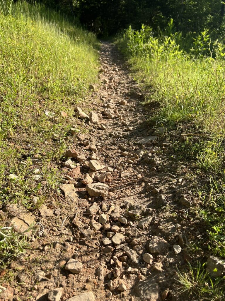
Loose reddish dirt and small rock on a sloping section of Northwest Arkansas trail
Loose dirt and small rock on a slope.
An eroded uphill hiking trail with both loose and embedded rock exposed in the tread
Both loose and embedded rocks. Water erosion will make this more uneven as time goes on.
Embedded rock making an uneven trail surface on a steep uphill section of Ozark singletrack
Embedded rocks on a grade. The ground is quite uneven as a result.
Flat plates of chert rock lying loose in the dirt tread of an Ozark hiking trail
Solid enough, but definitely uneven.
A narrow rocky singletrack hiking trail cutting through tall summer grass
Narrow tread through growing vegetation. This is where you make sure to check for ticks after your hike.
Broken white rock rubble covering a steep off-camber section of Ozark hiking trail
Both solid and broken rock covers the slanted trail.

Solid rock

Sometimes the erosion goes all the way down and the trail simply becomes the bedrock itself. Trail builders may even set big embedded rocks deliberately. Larger sections of rock like this are often called rock gardens.

The good news is that solid rock is the most reliable footing on a trail because it (usually) does not move. The bad news is that it can be slick when wet, so give a wet rock slab the same respect you would give ice and take it slowly.

A broad rock garden of pale limestone bedrock ledges climbing through winter woods
A rock garden of solid bedrock ledges, which is steady footing when it is dry.
Pale exposed bedrock forming the surface of an uphill Northwest Arkansas hiking trail
Solid bedrock. Excellent grip when dry, but surprisingly slick when wet.
Flat slabs of gray bedrock forming natural stair steps up a wooded Ozark trail
Natural rock slabs form steps in this rock garden.
A large embedded boulder forming a natural step in a rocky Northwest Arkansas hiking trail
Small sections of embedded rock like this are extremely common on Moderate and Challenging routes.

Roots

Trees on a thin-soiled hillside send their roots sideways, and the trail cuts across them. Roots are a very common trip hazard on our trails and the most consistently underestimated. They sit low, they are often the same color as the ground, and they are extremely slippery when wet.

A large exposed tree root crossing a rocky dirt hiking trail at ankle height
Roots are a trip hazard and slick when wet. Step on the dirt beside them, not the root.
Tree roots running across a slab of exposed gray bedrock on a wooded hillside trail
Roots and rock together, which can be difficult to traverse safely after a rain.

Water crossings

Creeks cut through many of our trail systems here, and not all of those crossings have a bridge. Some crossings are a line of stepping stones, some are a shallow run of water straight across the tread, and some are dry for most of the year and only appear after rain.

If your route includes a water crossing, waterproof shoes are a good idea, especially if it has rained recently. Rock sitting in moving water is slicker than the same rock out of it, so test each step before you put your weight on it. Water that is higher, faster, or muddier than usual is a good reason to turn around, and some creeks can come up quickly during and after heavy rain.

A wide creek crossing with large flat stepping stones set across the water on an Ozark trail
Large flat stones set across the creek. When the water runs higher, it is not passable without wading ankle-deep in the water.
A shallow low-water creek crossing where the trail drops down to rock and water
Low water over rock. Easy when it’s fairly dry, but a different proposition after heavy rain.
Shallow water running across a gravel trail crossing in the Ozark woods
Water running right across the trail. It gets deeper and faster if it has rained recently.
A rocky water crossing with the trail climbing steeply out of the drainage on the far side
It can be a challenge to find where to step without getting your feet wet.

Bridges & wood features

Northwest Arkansas is cut through with creeks and steep hollows, so a good deal of our trail mileage crosses something. Our bridges run from a few planks laid over a wet spot to steel spans above open water, and the variety is worth knowing before you meet it.

One thing is true of all of them. Wood decking gets slippery when wet, frosty, or covered in wet leaves, in a way that plain dirt does not. It even gets slippery when it’s just extremely humid, so be cautious when crossing them in wet, frosty, or humid conditions.

A low wood plank walkway with no railing carrying a hiking trail over soft wet ground
Wood with no railing or metal mesh.
A low wood plank bridge with wire mesh on the deck and no railing, crossing a small creek
No railing, but this one is very wide with metal mesh added for grip. But it can still get slippery when wet.
A flat wood bridge with rustic log railings and plain plank decking on a wooded trail
Flat, wide, and railed, which is about as easy as a crossing gets.
A wood bridge with wire mesh over the planks and log railings, crossing a rocky creek bed
Wire mesh over the planks with large railings.
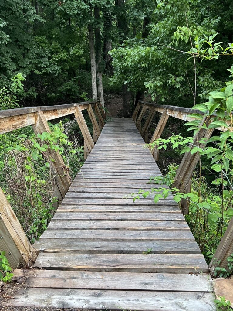
A wide wood bridge with rustic log railings and plain plank decking over a wooded gully
Bare planks with no mesh. The railing on this one is tilted away from the edge, so it’s not terribly helpful for support when hiking across.
A narrow wood plank bridge with a single railing beside a steep drop into a rocky gully
Railing on this bridge is offered on only one side, and you need to make sure you don’t accidentally step off the other side as there is quite a drop.
A curving boardwalk surfaced with wire mesh, built over exposed bedrock on a hillside
Mesh over the decking with a single railing on one side. Use the handrails for support when it’s wet.
A metal grate bridge with steel cable railing crossing a rocky cut below a bluff
This bridge is an open metal grate which has excellent drainage, but feels quite strange underfoot the first time you walk over it.
A curving elevated wood boardwalk climbing a slope through winter woods
Not every bridge is flat and level. This one is intentionally crooked since it was built primarily as a feature rather than a bridge. The surface has a rough texture to help with grip when it’s wet.
A narrow elevated wood walkway topped with wire mesh curving through open winter woods
Narrow wood features are common on bike-built trail. While built for bikes, hikers can walk them as well. Often these have a trail bypass so hiking the feature is optional.
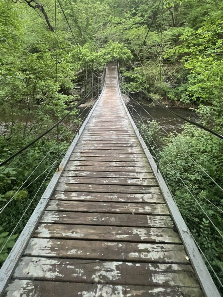
The swinging suspension bridge at Tanyard Creek, hung on steel cables above the creek in Bella Vista
This “swinging bridge” at Tanyard Creek moves under you, which is a bit unnerving at first.
Sugar Bridge, a steel span with an open metal grate deck, carrying the trail across the creek in Northwest Arkansas
Sugar Bridge is a metal bridge that spans the creek.

Ready to pick a trail?

Now that you know what is underfoot, go find some trails to hike!

  • Know what you’re looking for? Find a Hiking Route lets you filter by difficulty and distance.
  • New to hiking here? Getting Started on NWA Trails covers what to bring and how to share the trail.
  • Want to build up gradually? The Beginner’s Guide to Hiking Northwest Arkansas takes you from paved paths to the toughest trails, one short hike a week.
  • Need to know where to park? Trailheads and where to park to hike has parking details and directions for every trailhead we cover.
  • Not sure what the difficulty badges mean? Trail Difficulty Examples shows what Paved, Easy, Moderate, and Challenging each look like, with photos and video.

Welcome to the trails. Hike more. Live more.

Explore & Plan a Hike

  • Bella Vista
  • Bentonville
  • Trail Systems
  • Trailheads & Parking
  • Route Library
  • FAQs
  • Hike Event Generator

Guides & Resources

  • Getting Started on the Trails
  • Which Trails are Hikeable?
  • Beginner’s Hiking Guide
  • Trail Difficulty
  • Trail Surfaces
  • How to Use a Navigation App
  • Bella Vista Walks & Hikes

Hike NWA

  • History & Mission
  • Donate
  • Contact Us
  • Privacy Policy
  • Terms of Use
  • Donation Policy
  • Accessibility
  • Hike Lead Dashboard
  • Facebook
  • Instagram
  • Strava
  • Komoot

Copyright © 2026 · Hike NWA · A registered 501(c)(3) nonprofit organization
412 Town Center NE #1044, Bella Vista, AR 72714 · EIN: 42-2911997

Powered by
►
Necessary cookies enable essential site features like secure log-ins and consent preference adjustments. They do not store personal data.
None
►
Functional cookies support features like content sharing on social media, collecting feedback, and enabling third-party tools.
None
►
Analytical cookies track visitor interactions, providing insights on metrics like visitor count, bounce rate, and traffic sources.
None
►
Advertisement cookies deliver personalized ads based on your previous visits and analyze the effectiveness of ad campaigns.
None
►
Unclassified cookies are cookies that we are in the process of classifying, together with the providers of individual cookies.
None
Powered by